Thursday, 24 December 2015
Thursday, 10 September 2015
Do'nt go down the mine, Dad

Alighting
from the bus, I looked around for someone from whom to ask directions. The only
person in sight was a little old lady carrying two shopping baskets apparently
containing only Pringles, Rizlas, and chocolate bars. I asked her how to get to
the museum, and her response was “ Wow. Yeah, the museum. Cool. Might be over
that way. Hey. Cool,”
Yes, I was
in Wanlockhead, the highest village in Scotland.
I soon
located said “Museum of Lead Mining”,
and registered for the mine tour. At its peak, there were 47 lead mines and
several copper, gold and silver mines in a two mile stretch between here and
the neighbouring village of Leadhills.The lead mainly went to the Low Countries
by way of Leith.

A lot of
work has gone into re-opening this mine and making it suitable for visitors.


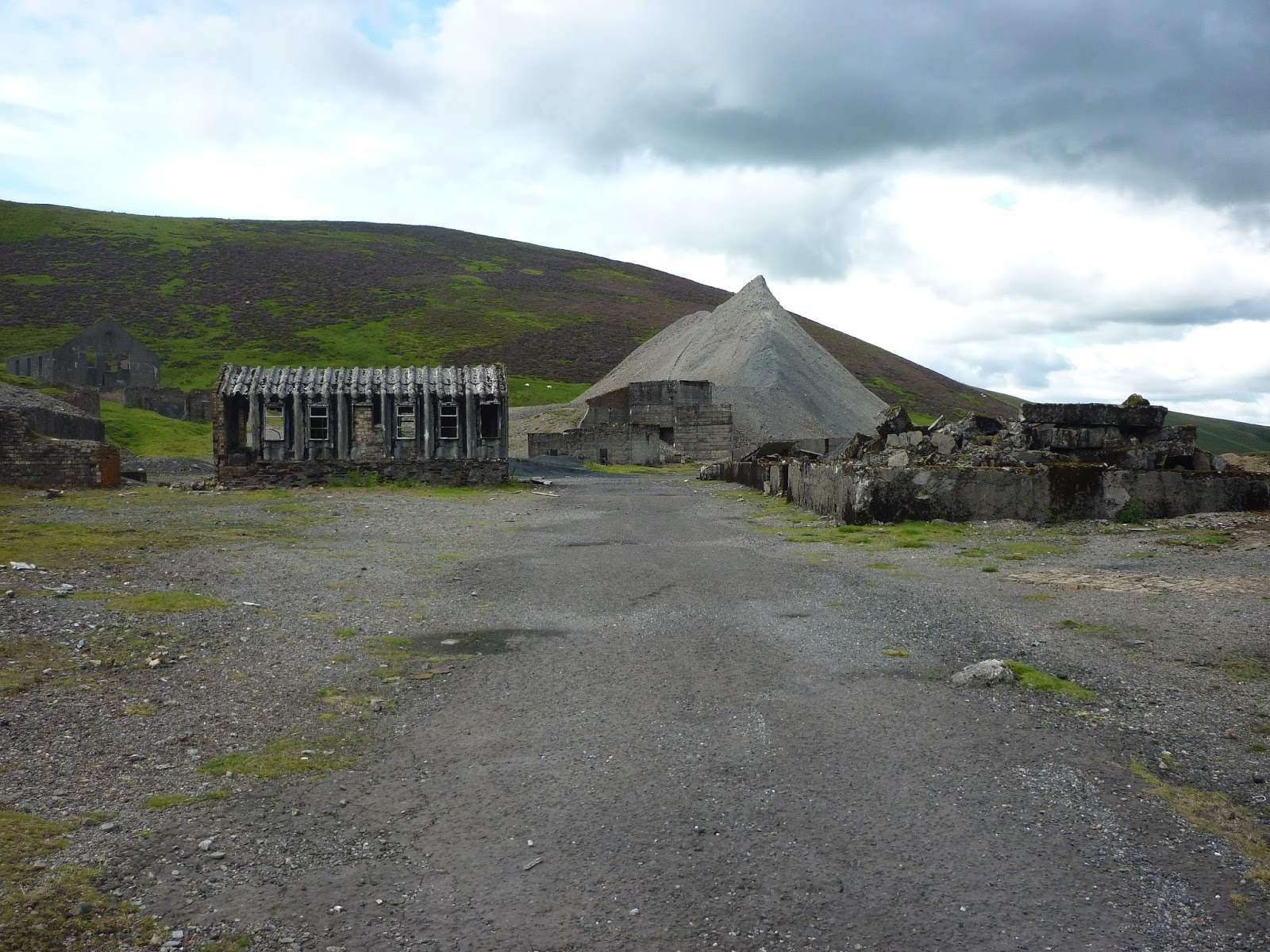
The galena
ore was dragged out on these sledges by wee boys, You had to earn your X-box in
those days.

The remains
of the smelter

One of the
deep mines. Some went down to 600 ft below sea level. Big deal ? Well yes, if
you remember that the surface here is 1500 ft above sea level.

The beam
engine - unusually operated by a water-filled, self-tipping bucket at the
opposite end from the pump.

A good day
out, including a wee rail trip from Glasgow to Sanquhar I realised that I hadn’t been in Ayrshire for
a ridiculously long time and resolved to remedy this at the earliest opportunity
.
I think Liege and Lief is in my Top 5 albums
I think Liege and Lief is in my Top 5 albums
Saturday, 29 August 2015
BLOGOF !

Yes, for a
limited period only, it’s “Blog one – get one free”
(Terms and
conditions apply. Remember, hillwalking can go down as well as up. By reading
this blog your house may be at risk.)
In an
attempt to further increase the popularity of this blog, I am including details
of two (not one – TWO ! Count them.) recent
walks, or bimbles, if I may borrow a mot juste from the lexicon of
Professor Sloman.
First up, we
have a wee wander up to the Bracklin Falls at Callander.
Callander is
an unlikely conglomeration of chip shops, ice cream parlours, and shops selling
tartanoiserie, which owes its popularity to its position a mere charabanc excursion distance from the great city of
Glasgow. Its situation at the edge of the Highland Boundary Fault (OK, I’ve
already done all the culpability jokes on this), allows the day-trippers to admire the glory
of the Dalradian metamorphics without exposing themselves to the risk of
altitude sickness.
Now, you can
drive up the hill to the tourist car park- if you’re a wimp. However, regular
readers know that I am made of stuff sterner than a German magazine, so I
walked up. This went well – nothing spectacular, but quietly pleasing.
From the car
park the path contours round the hill and then drops into the gorge at the
falls.


The original
bridge was swept away some years ago and replaced by this award-winning
structure.

Heading up
the gorge
At the top
of the gorge I crossed over and returned down the farm road. I was looking out
for the unsigned path off the road which led to this.


One of many
Red Wells or chalybeate springs where people used to come to drink iron oxide
infused water long before Barrs invented our other national drink. Still
trickling, to prove that, as Neil Young claimed, Rust Never Sleeps.

This bench,
next to the well, commemorates the founder of Callander’s leading Scots-Italian families. For years they
had the legendary Ben Ledi chip shop.
Part The
Second was a little spin up Myreton Hill.
But you don’t do hills. OM
Well, I do.
But verrrry slowly.

I had
already summited Myreton Hill as part of my compleation of the WhaMs. (Wee
hills above Menstrie) so this time I was not heading for the top, but following
the old pony track to the calcite mine.


No one seems
to know why anyone tried to mine a relatively common mineral such as calcite in
such a remote location. It certainly didn’t seem to be a success, and only a
small quarry and an adit blocked by a large gorse bush remain.
Good walk,
though – stretched the legs, expanded the lungs and worked what is left of the
heart. Onward and upward !!
Poor quality
clip , obviously taken on someone’s
phone, but worth it for a classic song by one of my favourite ladies.
Saturday, 15 August 2015
Now, there's something you don't see very often.

Well, not on
this blog anyway.
It being
that time of year again, I resolved to road-test my birthday socks with a
traverse of Sauchie Craigs. This year’s bad boys are ultra high-tech, featuring
wifi, satnav and differential cushioning. They also are designated “right” and
“left”, something I naturally only discovered after putting them on – on the
wrong feet.

The trek up
to the foot of the Craigs from the nearest bus stop is a long , steep, tarmac slog, so I
was delighted to scrounge a lift for part of the way.

As elsewhere
in Scotland, the post-war timber planting is now being harvested. I find it
quite spooky, and often disorientating, when a familiar patch of forestry is
suddenly transformed into one of these “Hiroshima” landscapes.


I’m very
slow on hills these days, so it took me a stupid amount of time to get onto the
top of the escarpment, but, hey, I had nothing else in my diary for the day,
and it doesn’t get dark until 10 o’clock, so suck it up.


That’s
Carron Valley in the distance. It was a relatively sunny day, and I had hoped
for good views, particularly north to the Highland Fault, but instead there was
an annoying haze (“all in my head”).


Blue spruce.

And a return
to civilisation at the quaint rural hamlet of St.Ninians.
Good game,
good game. About 8 miles and 900ft of upness.
Better than
a poke in the eye with a sharp stick. Indeed.
Thursday, 16 July 2015
Gartmorn (slight return)

Our story
starts here in 1694.
No. Wait.
Over a bit. There, that’s better.

Alloa Tower. erstwhile home of Sir John
Erskine, who “entertained” Mary Queen of Scots here. (nudge, nudge). Now, as
some of you may be aware, entertaining young queens doesn’t come cheap and Sir
John was skint. One day, while out serf-hunting with the dogs, he noticed Mr.
and Mrs. McBaldrick scraping black shiny stones out of the ground and setting
fire to them to amuse their 28 children.
Soon the
estate’s entire peasantry was busy 28 hours a day digging the black shiny
stones out of the ground and transporting them to the nearby Alloa docks for
onward shipment to people who had a use for them.
As the holes
got deeper, so they filled with water and children were being drowned at a
faster rate than their parents could replace them. Sir John called in a Welsh
mining engineer who decided that the best way to deal with the water was
…….with water ! A local burn was dammed and a system of water driven pumps was
set up. When more effective drainage systems became available, the water from the
dam was still used by several local mills (including a snuff mill) and a distillery.
The outflow ended up at Alloa docks where, at one time, it was collected in
large cisterns and released at low tide to flush the silt out of the harbour.


The dam wall
was raised several times and a weir was built on the river Black Devon with a
lade supplying top up water. At one time it was said to be the largest man-made
water feature in Europe.

Overgrown
lade
At various
times it has been used as a hydro-electric scheme and as a drinking water
reservoir. Currently it’s a country park and recreation facility.


The line of
the old railway to Alloa.

I believe
that, in a previous post, I told you ‘bout the swans (that they live in the
park)


Good walk –
about 4 miles bus stop to bus stop – negligible up. A stroll in the park,
really
Subscribe to:
Posts (Atom)