In which OM fails to find a Roman road and other minor misadventures on an otherwise lovely day.
Well, the weather has been pretty Octoberish , and Tuesday seemed to present a bit of a window. The plan was to walk from Soutra to Lauder via the Girthgait and a section of Dere Street. This was going to be a tight schedule for me, involving about 13 miles in 6 hours in order to make the bus connection at the finish. I had done this walk about 25 years ago, but in the opposite direction and, apart from that I have absolutely no recollection of the details.However the route is clearly marked as path/track all the way, and is in fact a Heritage Path as listed by Scotway. It seemed do-able and I wanted to push myself a bit.

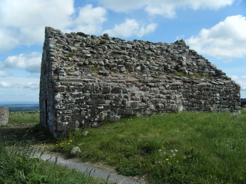
The bus driver let me off right at the Gilston road-end on the A68 and I toddled up the hill to Soutra Aisle with a huge panorama unfolding to the North and East, probably from Ninemileburn to Dunbar.

This small building, a chapel, is all that now remains above ground of what was a huge medieval hospital run by the Augustinian order. Excavations have revealed that remarkable medical practices were performed here, including herbal anaesthetics for amputations !
In fact this bleak bit of hillside has seen some history in it's time.

Dere Street, the Roman road from Corrbridge to Camelon, came this way, and subsequently the "Kings Road " also used a section of the same route , part of today's planned walk. Girthgait means Sanctuary Road, provided here and at Melrose Abbey.
After the battle of Nevilles Cross, the Scots were pushed back north, and for a time the border between Scotland and England passed through here

So far so good !

The future !! I saw 4 wind-farms today, and walked right through the middle of one. At no point during the day was I out of sight of a turbine. What to do ? stay in the house ? And to add insult to injury, I'm told I will be paying an extra £200 pa on my leccy bill to subsidise this nonsense. Nuff said.

The path was indistinct. No, let's be honest, the path was non-existent. At times you could imagine a section of embankment or cutting, but it soon disappeared. I searched for all the usual signs - nicks in the horizon, gates, styles etc but - zilch. Heritage path my arse ! Now, I knew exactly where I was at all times, the map details conformed to what I saw on the ground, I knew exactly where I was going, and I knew the bearing that would take me there. But no path.

The reason I carry a 75litre rucksack !
At one point I came to a wind farm access road which cut across the route at right angles. I walked up and down in both directions, but........

So it was a couple of hours of bog-trotting and gate-finding (I don't do fences!)

Exactly where I expected, I hit the cart track down to Kirktonhill farm and spotted this Historic Scotland sign indicating that I had just come along Dere Street. Aye right.

One for the geologists. I was vertical - the ground slopes !
There was no no chance of getting to Lauder in time to catch the bus, so I headed down to Oxton

Channelkirk Kirk.


In days of yore, whenever I was in the area, I would have popped in here for a pint or two and a good argument with mine host Bill Cowe, described in his obituary as "family man, superhero, landscape architect, and folkie."
He's no here anymore. The clue was in the word "obituary".
Enjoyed that, and the music too.
ReplyDeleteYou seem to be getting along okay.
:-)
Glad you enjoyed, Mr.S. The Small Step strategy seems to be working at the moment (helped by much appreciated encouragement from yourself and the other "usual suspects") Watch this space !
ReplyDelete